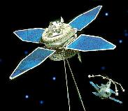
INTERBALL-1 [1995-039A]  - востовой зонд
[Трасса падения]
[Pre-launch information]
[Orbital State Vectors]
[Orbital Elements]
[673rd day]


INTERBALL-2 [1996-050C]  - авроральный зонд
[Pre-launch information]
[Information about launch]
[Orbital State Vectors]
[Orbital Elements]
[281rd day]
INTERBALL-1 Launch
August 03, 1995
Prognoz-M2 for the Interball-Tail mission with Magion-4 subsatellite
was successfully launched at 02:59:10.702 DMV on Aug 03 (23:59:10.702 UTC
on Aug 02) from LC43 of Plesetsk cosmodrome by the 8K78M (Molniya-M)
launcher. For details of the nominal launch profile see Pre-launch
information page.
 At 00:08:07UTC spacecrafts were inserted into transfer orbit. After
processing of range measurements received from Vorkuta, Kolpashevo,
Yeniseisk and Ulan-Ude tracking stations following orbital vector was
obtained for the transfer orbit.
Earth Fixed Greenwich (true equator, true equinox)
Epoch Date 1995 Aug 02
Epoch Time, UTC 23:41:05.912
X, km 4916.95818
Y, km -4969.24493
Z, km 0.00000
XDOT, km/s 1.85823710
YDOT, km/s 2.26519769
ZDOT, km/s 6.66933460
B, m*s^2/kg 0.025
Parameters of the transfer orbit were:
Nodal period, min 95.0027
Inclination, deg 62.8249
Min height, km 239.6466 *
Max height, km 826.9502 *
RAAN, deg 314.6970
ECI 1950.0 RAAN, deg 261.0626
Argument of perigee, deg 109.7367
Eccentricity 0.0423505
Semimajor axis, km 6903.1011
* - height above Earth's reference ellipsoide
At 01:04:15UTC spacecrafts were placed into main orbit.
At 00:08:07UTC spacecrafts were inserted into transfer orbit. After
processing of range measurements received from Vorkuta, Kolpashevo,
Yeniseisk and Ulan-Ude tracking stations following orbital vector was
obtained for the transfer orbit.
Earth Fixed Greenwich (true equator, true equinox)
Epoch Date 1995 Aug 02
Epoch Time, UTC 23:41:05.912
X, km 4916.95818
Y, km -4969.24493
Z, km 0.00000
XDOT, km/s 1.85823710
YDOT, km/s 2.26519769
ZDOT, km/s 6.66933460
B, m*s^2/kg 0.025
Parameters of the transfer orbit were:
Nodal period, min 95.0027
Inclination, deg 62.8249
Min height, km 239.6466 *
Max height, km 826.9502 *
RAAN, deg 314.6970
ECI 1950.0 RAAN, deg 261.0626
Argument of perigee, deg 109.7367
Eccentricity 0.0423505
Semimajor axis, km 6903.1011
* - height above Earth's reference ellipsoide
At 01:04:15UTC spacecrafts were placed into main orbit.
 Range and two-way Doppler measurements were received from Yevpatoriya
tracking center in 03:40 - 08:50 UTC time frame. Measurements were
carried out with P-400P and RT-70 aerials.
The first state vector was obtained at 09:30UTC.
The vector was in good agreement with another one obtained in Flight
Control Center, Kaliningrad.
After receiving additional portion of trajectory measurements from
Yevpatoriya the final state vector of the 1st flight
day was calculated.
Range and two-way Doppler measurements were received from Yevpatoriya
tracking center in 03:40 - 08:50 UTC time frame. Measurements were
carried out with P-400P and RT-70 aerials.
The first state vector was obtained at 09:30UTC.
The vector was in good agreement with another one obtained in Flight
Control Center, Kaliningrad.
After receiving additional portion of trajectory measurements from
Yevpatoriya the final state vector of the 1st flight
day was calculated.
INTERBALL-1 [1995-039A]
16 октября 2000 г. 17:05:30 МДВ
КА выведен из группировки. КА коснулся поверхности Атлантического океана
в точке -10°36'23" широты и -0°10'02" долготы

[Трасса падения]